Santa Cruz is investing heavily in road infrastructure and traffic safety improvements that are reshaping how drivers navigate the county. These projects directly affect accident rates, insurance claims, and legal liability in ways every driver should understand.
At Schaar & Silva LLP, we’ve seen firsthand how safety upgrades change the landscape of traffic accidents and claims. This guide walks you through what’s happening on Santa Cruz roads and what it means for your protection.
What Safety Projects Are Currently Underway in Santa Cruz County
Major Infrastructure Initiatives Reshaping Santa Cruz Roads
Santa Cruz County executes multiple infrastructure projects that directly reshape accident risk and driver liability. The Rural Highway Safety Plan targets six rural corridors-Highway 1 north of Santa Cruz city limits, Highway 9, Highway 236, Highway 35, Highway 129, and Highway 152-using crash data from 2014–2023 to guide investments in safety improvements. In 2021 alone, Santa Cruz County recorded 147 fatal and injury crashes, with bicyclists accounting for 49 victims, placing the county third worst in California for bicycle-related incidents according to the California Office of Traffic Safety.

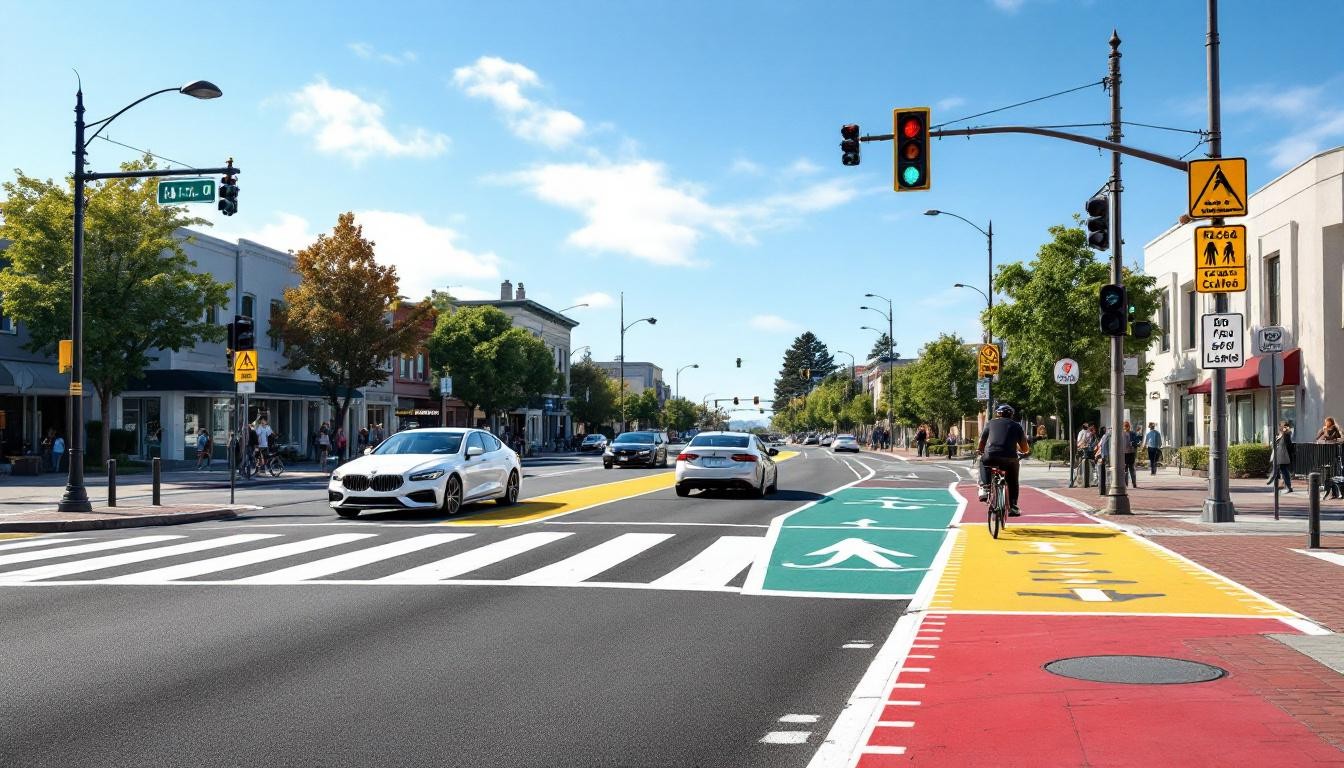
Highway 1 improvements between 41st Avenue and Soquel Drive, Bay/Porter to State Park Drive, and State Park Drive to Freedom Boulevard are under construction or in planning phases. Soquel Drive, Freedom Boulevard in Watsonville, the Bay Street corridor, and the 41st Avenue Corridor Plan represent major active work zones where drivers encounter lane closures, reduced visibility, and altered traffic patterns that increase accident exposure during construction phases.
Active Construction Zones and Immediate Driver Risks
Active construction zones present immediate driver risks that differ from completed improvements. Nighttime crashes in Santa Cruz County totaled 16 incidents in 2021, ranking 60th among California counties, and construction zones with reduced lighting amplify this risk. Speed-related fatal and injury crashes numbered 19 in 2021, and temporary speed reductions in construction zones-when drivers ignore them-create collision hot spots where liability determinations become complex. The Rural Highway Safety Plan’s data-driven approach identifies systemic crash patterns that contribute 5–15% of killed or seriously injured incidents across rural corridors, meaning project locations have documented high-risk histories. Caltrans is already lowering speed limits on Highway 9, and similar reductions on other improved corridors signal a shift toward slower, safer traffic flow that reduces impact severity when collisions occur.
Timeline and Funding Status of Safety Projects
The Coastal Rail Trail project and protected lane initiatives on Scotts Valley Drive advance alongside pedestrian improvements in Boulder Creek and Ben Lomond. These projects operate under a Safe Systems framework developed with Caltrans District 5, the Santa Cruz County Community Traffic Safety Coalition, and local agencies, meaning construction timelines reflect both engineering requirements and public safety coordination rather than simple infrastructure work. Completion timelines vary widely-the Rural Highway Safety Plan itself requires federal approval for HSIP and SS4A funding before individual projects can advance, meaning some improvements won’t materialize for 12–24 months. Once safety projects complete, evidence of prior dangerous conditions strengthens claims for accident victims who were injured before improvements took effect. For drivers navigating Santa Cruz roads today, understanding which corridors are under active construction, which have documented crash patterns, and which safety upgrades are completed versus pending proves essential to avoiding accident-prone zones and protecting yourself against liability claims tied to negligence in areas with known hazards.
How Safety Improvements Lower Crash Risk
Engineering Changes That Reduce Impact Forces
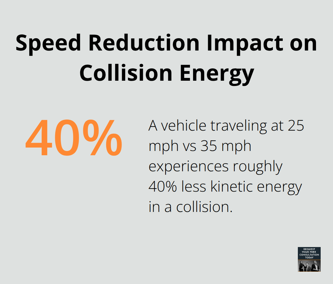
Santa Cruz’s safety projects directly reduce accident frequency and severity through concrete engineering changes that address the county’s documented crash patterns. The Rural Highway Safety Plan targets six corridors using crash data from 2014–2023, and this data-driven approach means improvements address real hazards, not theoretical ones. When Caltrans lowers speed limits on Highway 9 and similar corridors receive design changes that slow traffic, impact forces decrease proportionally-a vehicle traveling at 25 mph versus 35 mph experiences roughly 40% less kinetic energy in a collision. Protected bike lanes, clearer intersection sightlines, and signal timing upgrades eliminate the crash mechanisms that generated 147 fatal and injury crashes in Santa Cruz County during 2021 alone.
Addressing High-Risk Corridors and Vulnerable Road Users
The county ranked third worst in California for bicyclist incidents that year with 49 victims, and protected infrastructure directly addresses this vulnerability by separating cyclists from vehicle traffic rather than relying on driver awareness. Highway 1 improvements between 41st Avenue and Soquel Drive, along with Freedom Boulevard work in Watsonville, specifically target corridors where collision history shows concentrated risk. Speed-related crashes numbered 19 in 2021, and narrower travel lanes combined with visual cues from new pavement markings naturally encourage slower driving without enforcement. Improved lighting in construction zones and completed projects eliminates nighttime crashes (which totaled 16 incidents in 2021) by removing a major accident trigger.
Traffic Flow and Congestion Reduction
Reduced congestion from better traffic signal coordination and lane configuration changes produces measurable safety gains beyond individual project sites. When drivers encounter smoother traffic flow with fewer stop-and-go cycles, rear-end collisions and intersection crashes decline-congestion creates the compressed following distances and rushed decisions that generate claims. The Safe Systems framework guiding Santa Cruz improvements integrates engineering, enforcement, and education, meaning a completed protected bike lane includes driver education campaigns and periodic enforcement sweeps rather than infrastructure alone. Cities like Seville and Denver deployed protected bike lanes rapidly and saw bicycle commuting increase up to 430% while overall traffic calmed and safety improved across all modes.
Infrastructure Design That Reduces Collision Severity
Santa Cruz drivers navigating improved corridors will encounter infrastructure designed to make mistakes less catastrophic-wider shoulders, better drainage to prevent hydroplaning, and intersection designs that reduce conflict points where vehicles and pedestrians occupy the same space simultaneously. For accident victims injured before safety improvements take effect, documentation of prior dangerous conditions strengthens liability claims and settlement negotiations, since evidence of known hazards that the county failed to address earlier becomes relevant to negligence arguments. As these projects progress, the legal landscape surrounding traffic accidents in Santa Cruz shifts, making it essential to understand how completed improvements and ongoing construction affect liability determinations and claim outcomes.
How Safety Improvements Change Accident Liability
Infrastructure Changes Shift Liability Assessments
Safety improvements across Santa Cruz County fundamentally alter how liability gets determined after accidents occur. When a driver causes a collision on a newly improved corridor with protected bike lanes, better signage, and reduced speed limits, courts and insurance adjusters evaluate the accident differently than they would have before these changes. A driver who hits a cyclist on Highway 9 after Caltrans lowered the speed limit faces stronger liability exposure because the infrastructure now makes safe driving at posted speeds physically easier-the narrower lanes and visual cues naturally slow traffic, so a collision suggests driver error rather than road design failure. Insurance companies recognize this shift and adjust their liability assessments accordingly.
If you caused an accident on a corridor that received safety upgrades in the past 18 months, the other party’s attorney will argue that improved conditions made the collision preventable, strengthening their negligence claim. The Rural Highway Safety Plan identified systemic crash patterns contributing 5–15% of killed or seriously injured incidents across six rural corridors, meaning those locations had documented hazards. If you were hit on Highway 1 or Highway 9 before improvements took effect, that crash data proves the county knew the road was dangerous, which supports arguments that negligence caused your injuries rather than unavoidable circumstances.
Documentation Strategies for Post-Improvement Accidents
Evidence collection after an accident in improved versus unimproved areas requires different strategies. Photographs showing new infrastructure, recent construction completion dates, and updated signage become critical exhibits that demonstrate what safety conditions existed at the time of your accident. If you suffer injury after a project finishes, obtain records from Caltrans or the County of Santa Cruz showing when improvements were completed-this timeline proves whether the safer infrastructure was operational when your accident occurred.

For accidents in active construction zones on Soquel Drive, Freedom Boulevard, or the 41st Avenue Corridor, gather documentation of temporary lane closures, reduced visibility conditions, and speed reduction signs, since these temporary hazards often create liability disputes about whether construction itself contributed to the collision. Insurance adjusters scrutinize accidents in construction zones more carefully because temporary conditions complicate fault determinations.
Legal Strategy and Project Timeline Evidence
When working with legal counsel after an accident in Santa Cruz, provide your attorney with specific details about project status: was the corridor under construction, recently completed, or fully operational? This information directly influences how your lawyer frames negligence arguments and settlement negotiations. Accidents occurring before safety projects complete carry different liability implications than those happening after improvements take effect. A collision on an unimproved stretch of Highway 1 before the 41st Avenue to Soquel Drive project finished demonstrates that the county maintained a known dangerous condition, whereas the same accident after completion suggests the driver failed to adapt to safer infrastructure. Your attorney uses project timelines and safety data to strengthen accident claims for injured drivers and cyclists throughout Santa Cruz County.
Final Thoughts
Santa Cruz traffic safety improvements reshape accident risk across the county in measurable ways. The Rural Highway Safety Plan, Highway 1 corridor work, and protected bike lane initiatives directly address the documented crash patterns that produced 147 fatal and injury crashes in 2021 alone. As these projects progress from construction zones to completed infrastructure, drivers benefit from slower traffic, better visibility, and separated cycling facilities that reduce collision frequency and severity.
If you suffer injury in a traffic accident in Santa Cruz, the project status and timeline matter significantly for your claim. Accidents in active construction zones require different evidence strategies than those on completed corridors, and documentation showing when safety improvements took effect strengthens your position in liability negotiations. Courts recognize that safer infrastructure makes collisions more clearly attributable to driver error, which affects how adjusters evaluate fault and settlement value.
When you need guidance navigating your accident claim, contact our legal team to discuss your case and recovery options. We at Schaar & Silva LLP provide medical bill assistance, property damage claim evaluation, and connections to support specialists who recognize the trauma accidents cause.